Monday, September 17, 2012

Return east: Day 3.1, Devil's Tower to Rushmore


IT'S LIT UP FROM THE OTHER SIDE!!

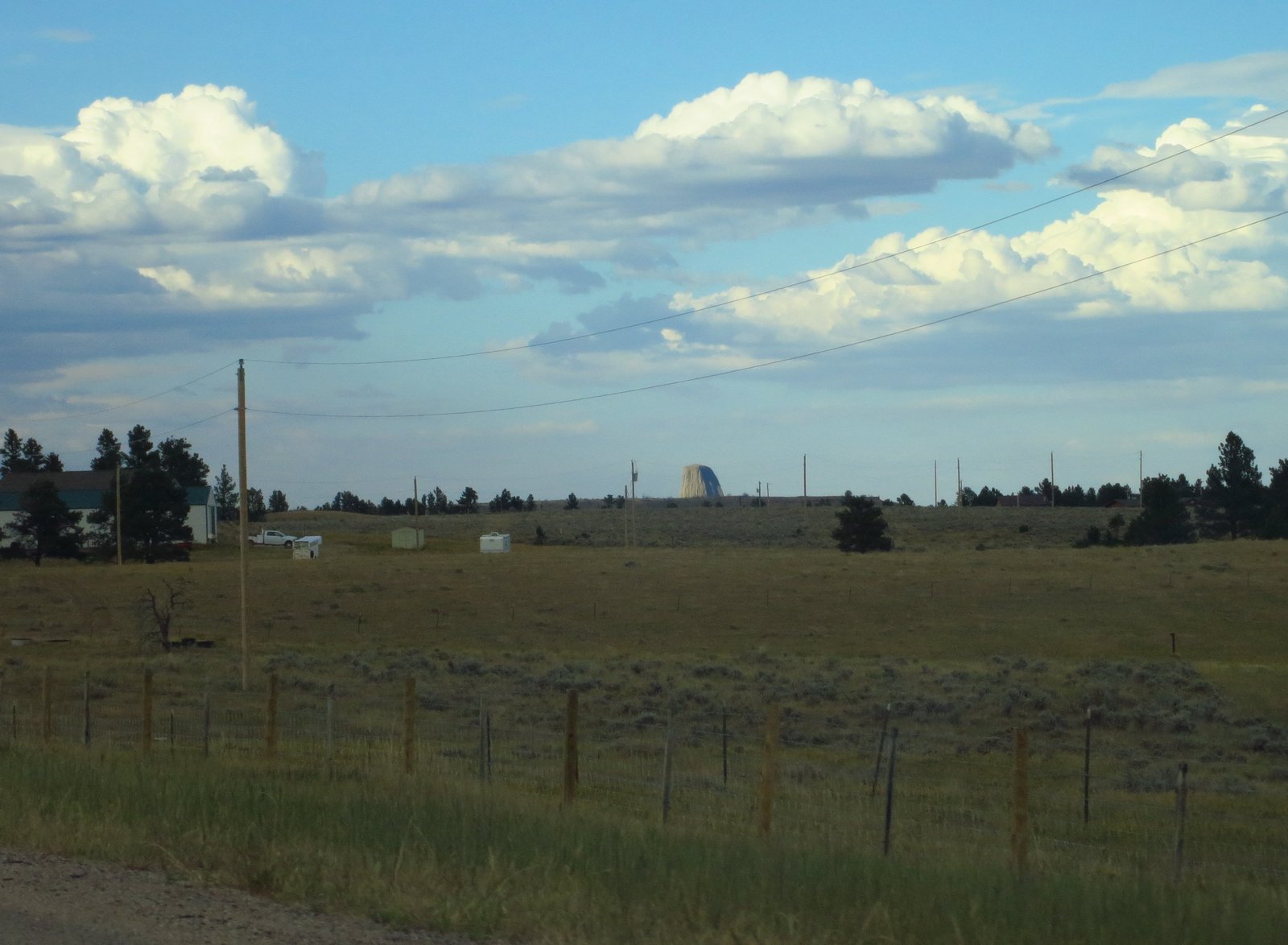
As you can see, it's a very nice campground, nice old trees and the tower right there. Not so nice: just outside the monument, at a little junction with a post office, a convenience store, and a KOA, was probably the only music venue for 100 miles, and they were playing a very loud rock concert with a band covering late standard, fairly boring late 90s mainstream rock. Good thing I had earplugs!
 
Prairie dogs...prairie doggin'.


Sammy in the Prairie Dog Town (the official name). Prairie dog burrows stretch as far as the eye can see across this huge flat area. Some burrows go under the concrete walkways.


A work of art by a Japanese guy. He also installed sculptures at the Vatican and at a sacred Buddhist site.


Some turkeys wandered through the campground but Sammy kept me safe.


Seriously, right Greg?


A big cave, apparently. Below is a map of Jewel Cave, which, according to Wiki, has 157 mi of caverns. I didn't get to go in because access is limited to ranger-guided groups and I would have had to wait around a while.


Detail of the map.


What it might have looked like, had I been inside:

 Then I went to Mt Rushmore. Big carvings which may look familiar:


I ran a very brief loop around the grounds below the carvings themselves, because Sammy was in the hot car.

Interestingly, again according to wikipedia:
Mount Rushmore is controversial among Native Americans because the United States seized the area from the Lakota tribe after the Great Sioux War of 1876. The Treaty of Fort Laramie from 1868 had previously granted the Black Hills to the Lakota in perpetuity. 

Oops, sorry guys!


Then we drove to a trailhead to the nearby Black Elk Wilderness we (I) had some  PB&J, followed by a hike.


At left is Mt Rushmore's backside. Also neat.


Other mountains. Quite a bit of rock climbing to be had around here.


Then we got back in the can, I mean car, and drove down to Badlands NP. I was thinking of skipping it in the name of laying down some actual miles for the day, but a lady working at a highway rest area/visitor center said I'd end up being disappointed if I drove right by it (it's not much off I-90). It turned out to be very cool. Next installment.

Thursday, September 13, 2012

Return east: Day 2

Got up, ate breakfast, shook the rain off the tent (rained overnight) then hit the road. 

First stop was (exciting) the Buffalo Bill Dam. Buffalo Bill was quite a character. This was the tallest dam in the world at the time it was built and Buffalo Bill had to do with it. I took pictures of the reservoir but didn't go in to see the dam itself.
Then I drove through a tunnel and rolled into Cody. They love Buffalo Bill there.

Then it was flat and open for a while.


Here is a really good song about driving:

Idaho by Andy Friedman & The Other Failures on Grooveshark


And when I got there my left arm was tan.


 Sammy is bored.


Near Greybull, WY, there is a little airfield with a bunch of vintage aircraft around. Eventually it's going to be a museum dedicated to firefighting aircraft.

 See http://personal.tctwest.net/~flight/photo.html.

A Canadian Royal Air Force C-119 Flying Boxcar, apparently with a JATO unit up top.


C-45 Twin Beech Smokejumper.


 There were loads more, too. These were just the ones I could see clearly without climbing a barbed-wire fence:

View Larger Map


Then it was on up into the Bighorns.


Up Shell Canyon, just east of Shell, WY. Quite exciting. A couple times per mile were signs indicating which geological time period was exemplified by the canyon wall at that elevation and location.


Geology is possible!!!!

Shell Falls.


Granite Pass gave way to a huge flattish area, a prairie on a butte.


Interesting cliff bands laid into the mountains here, descending US-14 off that plateau after many miles. Horseshoe Mountain.

Is there any other kind of woman? ...just kidding, Rosie...


Ah, a civilization.


I guess something had to fill the vacuum left by the vanishing buffalo, and civilization was what showed up.


To Devil's Tower! Land ho!

 
Devil's Tower was created when three sisters were out with one brother, and for some reason that brother was transformed into a bear. This bear tried to snatch them up, but then a tree stump erupted out of the ground, raising the sisters up out of the bear's reach, and as it sank its claws into the bark it was raked with scratches. However, the stump erupted a little too fast, because the sisters were actually catapulted into the heavens where they became the Pleiades. 

I may be missing some of the subtlety of the original.

All this happened before the cows brought civilization to Wyoming (see above).

Or maybe it was an underground hollow filled with liq-uid hot mag-ma which later cooled, causing stress concentrations at the boundaries of columnar crystals resulting in long cracks, but making the magma-rock more resistant to erosion than the surrounding earth. That sounds good too.

Teepee included for scale.


Tree included for scale.


Birds soaring next to the tower, apparently taking advantage of airflow patterns in the wake of the tower.


I hope you're not getting tired of photos of Devil's Tower. Oh, believe me, I have more:


I camped at the NPS campground right the base of the mountain. It's really nice.
More tower pictures tomorrow...illuminated from the other side.

Wednesday, September 12, 2012

Trip back east: day 1

On Friday, 8/31, at the crack of 3:45, I had the Ru loaded and ready to go. I considered punting and staying one more night, but my feet were itching so I hit the road. I drove up the Moose-Wilson Road sad to be leaving. Thankfully, I had a cooler full of beer, pork, salmon, and salad courtesy of Moe. Yeah, that eased my sorrow.

 Swung it out onto 89. The weather was not altogether encouraging.

This again?!


I drove through a little rain up into Yellowstone, but not too much. I hit hardly any rain the whole way back, actually. Here's Yellowstone Lake, in a spot with some geothermal activity:


This road feels just like Acadia, actually--rolling hills and great views of big water.


Fire damage from 1988 I think.


Matchstick forest.


 Sylvan Pass: over the top.
 

What's that up ahead?
 

HOLY CRAP A BUFFALO WALKING DOWN THE HIGHWAY!!


Classic Jellystone.


Shoshone National Forest ahead. Awesome.


I got gas, then looked at the map. It was 8:30 at this point and I was way short of Bighorn National Forest, my original goal. Instead of driving, and starving (it's a pain to pull out the cooking gear without unpacking everything else) until finding a campsite in Bighorn, I backtracked 10 minutes to a FS designated campground and spent the night there. Definitely the right move, as I wouldn't have wanted to miss the next day's scenery in darkness.