Thursday, August 30, 2012

Mountain biking around Jackson

Tuesday afternoon I finally replaced my cell phone. Its battery was so dead that I couldn't talk for 10 minutes without plugging it in. I bought a new one, with a cheaper payment system, which should save me money each month. Should have done this a while ago.

The old Nokia brick. This phone made it 9 years, probably 3-4 times the average life of a cell phone in America. All the buttons usually still worked.
 
Then I went mountain biking to the top of Snow King Mountain.
A big fire NNE of Jackson, near Dubois, which flared up a couple days ago.

High peaks.

From the top of Snow King, looking E into the terrain where Erik, Annmarie, and Rosie and I did a long bike ride. No wonder we were tired! 

On the way down the Ferrins Trail I pinch-flatted. I think this is my first flat tire since last summer, on any bike.

 Tuesday night I began stripping all the parts off the Orange Demon. Poor bike, it came to Jackson in one piece, and will be returning to Boston in a box, and divorced from its frame. I will buy a $100 replacement frame from Nashbar or Performance to hang the old parts on, to make a dedicated commuting/utility bike.


 Yesterday, Tom and I went mountain biking on Philips Ridge. Looking towards town from the ridge:

On the opposite side of the ridge sits Rendezvous Peak:

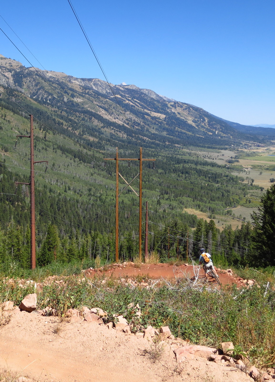
Great view down into Philips Canyon.


Looking N up the range, Rendezvous Bowl in the resort bounds high left:

Tom:


Me:


This trail is about 2200 feet of descent in only about 2.5 miles, lots of it rocky, washboarded, or technical. Very tiring!

 Riding Philips Ridge was one of the items on our summer bucket list, which we came reasonably close to completing:


Tuesday, August 28, 2012

A three state day, then boating on the Snake

Woke up the next morning, and drove over the Bear Lake Summit (the pass), and down along Bear Lake, through Montpelier, ID, then over through Afton, ID, and up to Jackson.

Bear Lake Summit, I caught it as the morning mist was burning off.


In Montpelier, ID, I stopped at a FS ranger station (closed) which is also a museum for the Oregon Trail. What this has to do with Bigfoot, I have absolutely no clue. I guess I should have asked.

 I decided to try to hike Meade Peak, the tallest in the area and apparently a short hike from the end of the dirt road shown on this map.

Up US-30. Amber waves of grain.

Up Georgetown Canyon. No more grain. No more road signs, either, and I overshot the Right Hand branch road by at least 5 miles, but it was pretty nice driving. The amount of publicly managed Forest Service land in the west is completely staggering. FREE for you to just roam around at will, camp wherever you want, interlaced with massive networks of clear, driveable dirt roads, (presumably) safe bridges, gravel double tracks, and pack- and hiking trails. And people are always complaining about the government around here?
 
Anyway, that "Righthand Branch Road" was pretty much a doubletrack and soon branchhes were brushing both sides of the car and I decided not to push my luck. Breaking the car a week before a cross-country drive would be bad. So I did an austin powers turnaround and headed back to the highway.

It doesn't look bad in this picture, but that is a steep, loose hill with big rocks, and this was almost the only place I could turn around, so I wouldn't have to reverse out the way I came.

Passing through Afton, WY, I decided to stretch the legs (mine and Sammy's) with a hike to the WORLD'S LARGEST INTERMITTING SPRING, called Periodic Spring.

Driving up Swift Creek. Dammed, and with a tiny hydroelectric plant, downstream from this photo. A very dramatic road with lots of cliffs on each side.


The spring is up a hug cleft below that long cliff ahead.

Periodic Spring is the largest of just a small handful of such intermittent springs in the world. Want to guess how many Yellowstone has? ZERO!!! Take that, "World's first national park"!

These ugly bugs were everywhere right at the output of the spring.

I got up there and it was flowing, then it went dry after ten minutes. Dry:

Waiting around for it to resume flow, I played with the camera.

After 15 minutes, it resumed. Now I believe the signs.


Should come back here sometime in winter and ski it? Well, long approach because the road's not maintained.

Swimming hole. Quick plunge, was really cold.


Then headed back to the car and kicked it back to the Village.

On Sunday, had an awesome time duckie-boating down Snake River Canyon with Mark, Sean, and their friend Jackie.
Snake River Whitewater Photo & Video: 10-Noon  082612-Pvt-1130-Pvt (18)

Snake River Whitewater Photo & Video: 10-Noon  082612-Pvt-1130-Pvt (20)


Jackie:
Snake River Whitewater Photo & Video: 10-Noon  082612-Pvt-1130-Pvt (23)


Days like this certainly reinforce how whitewater could become addictive.

A Beehive State of mind


Rosie took the 6 AM airport shuttle from the hotel on Friday morning, graciously allowing me to sleep until 8 or so. I was planning to take the scenic route to Jackson. Checked out of the hotel, then drove up Little Cottonwood Canyon to see what the fuss is about up there. But not before driving the wrong way for half a block right out of the hotel parking lot down on of the four or five lane streets (this was totally impossible to tell, and someone else did the same thing right next to me. The wave of cars coming at us out of the green light was a good hint that something was amiss.).


Got up to Alta ski area at the top of LCC. It's one of the more renowned ski resorts in the US and mountaineering-level descents are present in every direction out of the resort ropes.

Baldy Peak.

I wanted to go hiking with Sammy, but for watershed protection dogs aren't allowed. A guy told me that technically I could get pulled over and cited just for having him in the car. So back down to SLC.

I didn't take a good picture of the range itself, but it's impressive, and its proximity to the city is impressive. By comparison to Boston, it's as if the Blue Hills, just outside of the city lines to the south, were 11,000 feet tall, several times greater in geographic area, and pulled down 500 inches of continental powder per year. 

Looking down to the city.

Then I figured I should go down to the Great Salt Lake. Mountains right by the lake, too.

Swam in the lake. Actually not that salty, compared to the ocean.

Beach walk.

Then we drove up US-89 into Logan. Motoring up the pass right off the valley:

Heading down into Logan.
Driving up Logan Canyon.

Drove up to the Tony Grove trailhead for a late afternoon hike. Here's an apparently natural amphitheater made of rock:

Topped out on Naomi Peak, border of the Naomi Wilderness, tallest mountain in the Bear River Range at 9975 ft.

Sammy is on pika patrol.

Pano from the summit. photosynth Link.


I can has PB&J?


Oh it just got serious.

After dinner in the trailhead parking lot, camped in the back of the Ru on a forest service road a few miles below the top of the pass.